


Marietta Precinct, Saunders County, Nebraska
About
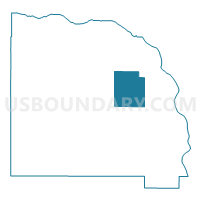
Outline

Summary
| Unique Area Identifier | 613885 |
| Name | Marietta Precinct |
| County | Saunders County |
| State | Nebraska |
| Area (square miles) | 30.29 |
| Land Area (square miles) | 30.21 |
| Water Area (square miles) | 0.08 |
| % of Land Area | 99.73 |
| % of Water Area | 0.27 |
| Latitude of the Internal Point | 41.25524720 |
| Longtitude of the Internal Point | -96.51611080 |
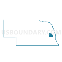
Maps

Graphs
Select a template below for downloading or customizing gragh for Marietta Precinct, Saunders County, Nebraska


Neighbors
Neighoring Voting District (by Name) Neighboring Voting District on the Map
- Cedar Bluffs Precinct, Saunders County, NE
- Center Precinct, Saunders County, NE
- District 4 Precinct, Saunders County, NE
- Wahoo Rural Precinct, Saunders County, NE
- Yutan Precinct, Saunders County, NE
Top 10 Neighboring County Subdivision (by Population) Neighboring County Subdivision on the Map
- Union township, Saunders County, NE (1,682)
- Pohocco township, Saunders County, NE (1,185)
- Marietta township, Saunders County, NE (843)
- Center township, Saunders County, NE (628)
- Leshara township, Saunders County, NE (526)
- Stocking township, Saunders County, NE (453)
- Wahoo township, Saunders County, NE (410)
- Marble township, Saunders County, NE (409)
- South Cedar township, Saunders County, NE (245)
Top 10 Neighboring Place (by Population) Neighboring Place on the Map
Top 10 Neighboring Unified School District (by Population) Neighboring Unified School District on the Map
- Fremont Public Schools, NE (29,879)
- Wahoo Public Schools, NE (7,198)
- Yutan Public Schools, NE (2,159)
- Mead Public Schools, NE (1,510)
Top 10 Neighboring State Legislative District Upper Chamber (by Population) Neighboring State Legislative District Upper Chamber on the Map
Top 10 Neighboring 111th Congressional District (by Population) Neighboring 111th Congressional District on the Map
Top 10 Neighboring Census Tract (by Population) Neighboring Census Tract on the Map
- Census Tract 9683, Saunders County, NE (4,891)
- Census Tract 9684, Saunders County, NE (4,221)
- Census Tract 9681, Saunders County, NE (3,210)